


 Shanxi










 Lüliang
County-level
Li Shi District
Cliffside pavilions of Anguo Temple preserve the study lodge of incorruptible minister Yu Chenglong in Lishi, administrative heart of Lvliang.
 MUZIChinese Matrix
 Lüliang
The Lüliang Mountains define western Shanxi, where Yellow River hills, coal resources, and forest-grassland ecology shape the regional setting.
 Qikou Ancient Town
Wooden ferries line Qikou’s Yellow River port beneath Li Jia Shan’s clustered cave dwellings on the loess hillside.
Open the entryThe regional profile of Lüliang begins with the concrete evidence “The Lüliang Mountains define western Shanxi, where Yellow River hills, coal resources, and forest-grassland ecology shape the regional setting.” The clue links spatial form with everyday experience, giving the regional idea a concrete setting and human scale. Long-term change preserved, adjusted, and transmitted these relationships, showing how environmental influence and community action worked together. These interactions provide a factual basis for understanding the connections, distinctions, and continuities between Lüliang and nearby places. Its significance lies in connecting regional geography, historical continuity, and cultural difference through checkable local evidence about Lüliang.
Lüliang
County-level
Cliffside pavilions of Anguo Temple preserve the study lodge of incorruptible minister Yu Chenglong in Lishi, administrative heart of Lvliang.
 Lüliang
County-level
Liu Hulan Memorial honors the fearless young heroine in Wenshui, ancestral homeland of Empress Wu Zetian at historic Zetian Temple.
 Lüliang
County-level
Xuanzhong Temple stands as the ancestral cradle of Pure Land Buddhism in Jiaocheng, nestled below millennia-old twisted cypresses on Mount Guashan.
 Lüliang
County-level
Jin-Sui Border Region Historic Memorial preserves wartime headquarters at Caijiaya in Xingxian, bordered by the mighty Yellow River.
 Lüliang
County-level
First Ancient Town of Nine-Bend Yellow River, Qikou preserves stone wharf shophouses in Linxian, facing terraced cave dwellings at Lijiashan.
 Lüliang
County-level
Historic timber halls and colorful murals at Xiangyan Temple overlook riverside bluffs in Liulin, famous for plump sweet Liulin Wood Dates.
 Lüliang
County-level
The grand horseshoe meander of Yellow River First Bend inspired Mao Zedong poem Snow in Shilou, where Shang Dynasty bronze dragon vessels were found.
 Lüliang
County-level
Ten thousand mu of blossoming multicolored potato flowers carpet rolling hills in Lanxian, source of the pristine Lanhe River valley.
 Lüliang
County-level
Mount Beiwudang Taoist sanctuaries balance atop sheer granite precipices in Fangshan, ancestral home of celebrated honest official Yu Chenglong.
 Lüliang
County-level
Traditional folk paper cutting art of Zhongyang Paper Cutting flourishes in Zhongyang, blessed with ancient pine groves on Mount Baiwashan.
 Lüliang
County-level
Secluded Taoist shrines and waterfalls on Mount Yunmengshan frame Jiaokou, home to Eastward Expedition wartime command headquarters.
 Lüliang
County-level
Handcrafted Shadow Puppetry and Marionette Puppetry perform centuries of folklore in Xiaoyi, beside lakeside parklands at Shengxi Lake.
 Lüliang
County-level
Six millennia of brewing history at Xinghuacun Village craft legendary Fenjiu in Fenyang, home to exquisite Jin dynasty murals at Taifu Temple.
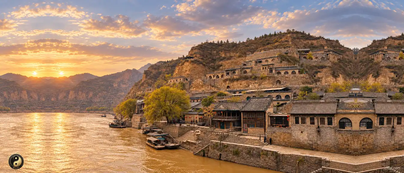 Qikou Ancient Town
No.1 town on the Yellow River's nine bends; key ferry port for western Shanxi merchants; Lijiashan cave dwellings are the Potala Palace of the Loess Plateau.