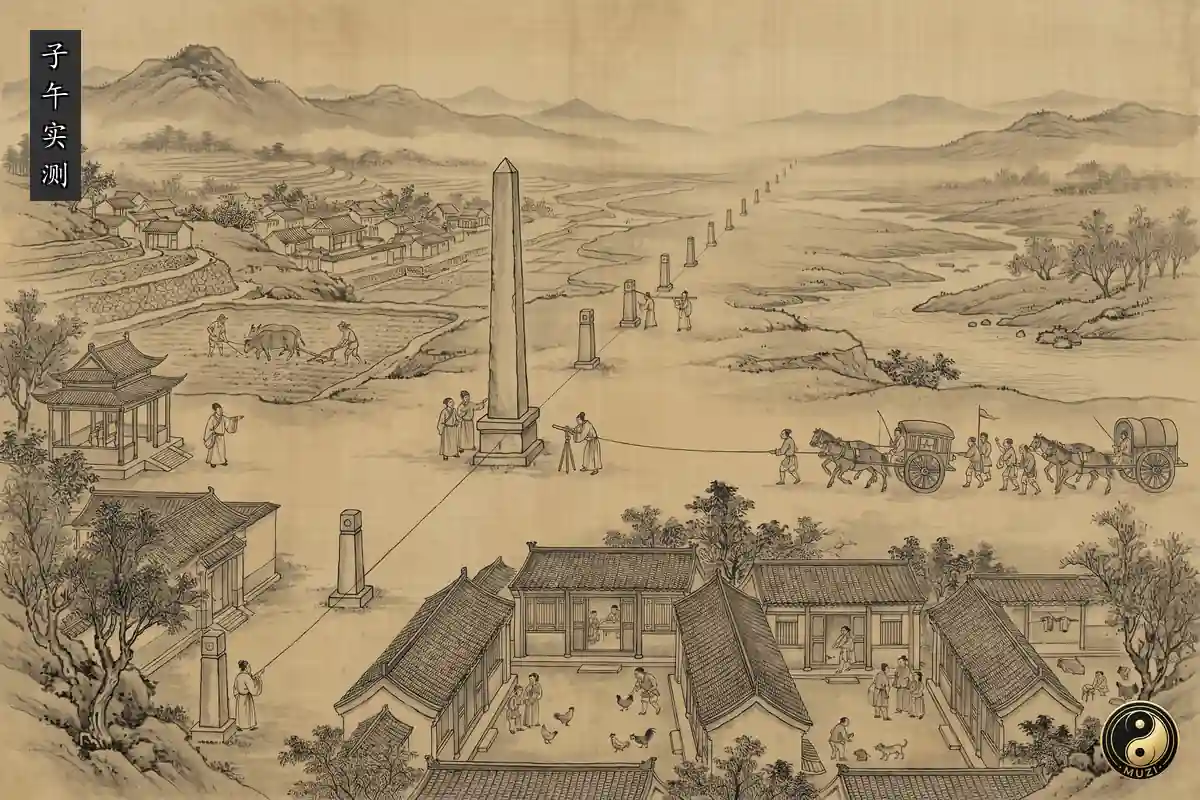



Meridian Measurement puts heights in the sky, distances on the ground and the territory of the state on one scale that can be checked. As one travels north, the pole rises higher in the sky; and when a gnomon is set up at noon on the same day, the length of its shadow differs from place to place. By comparing the height of the pole, the length of the shadow and the measured distance between a northern and a southern place, one can work out how many li one must travel on the ground for the height on the celestial sphere to change by one degree. It is not empty talk about longitude and latitude, but a method of turning the observation of the sky into the measurement of the land.
In the twelfth year of Kaiyuan in the Tang (724), according to the Treatise on Astronomy in the Old Book of Tang, the court "ordered the Grand Astrologer to measure the shadow at Jiaozhou", and the Director of the Astrological Service, Nangong Yue, chose level ground in Henan for measurement; the shadow and the height of the pole were recorded at each place, such as "the pole stands twenty-six degrees and six fen high", and from them came the figure "three hundred and fifty-one li and eighty bu make a difference of one degree", that is, over that distance from south to north the height of the pole changes by one degree. The treatise also records that "the monk Yixing, in revising the Dayan tables", took part, which shows that the survey was tied to calendar reform, organised by the court and completed by observations in many places. Guo Shoujing of the Yuan led the "Survey of the Four Seas", and the Treatise on Astronomy in the History of Yuan records that "the places where the shadow was measured across the four seas at that time numbered twenty-seven", so that observation grew from the instruments of one court into a network across regions. In the Kangxi era of the Qing, according to the biography of He Guozong in the Draft History of Qing, the Kangxi Emperor "ordered the making of the Complete Map of the Empire, fixing its bearings by degrees of the heavens, one degree equal to two hundred li". The three records are linked, but the Tang, Yuan and Qing efforts must not be described as one single project.
Its effect on history lies first in how the state came to know its land. The Tang found the number of li in one degree from figures taken at places from south to north; the Yuan spread its shadow-measuring places to twenty-seven, so that distance, direction and region no longer depended on observation at one place; and the Qing drew the Complete Map of the Empire with its bearings fixed by degrees of the heavens and one degree equal to two hundred li, applying an astronomical scale to a map of the whole realm. A study of the history of Chinese efforts to determine longitude at sea notes that Chinese maps served administrative, land-survey and topographic needs; measurement thus entered the arrangement of the calendar office, the system of observation and administrative space, and the Complete Map of the Empire was not just a finished drawing, but a geographical result of governing territory.
Its influence on culture came from a new habit of seeing. The shadow of the gnomon made north and south, the length of the day and scale visible on the ground; the height of the pole let the direction of a long journey and the position of a place be discussed in a common astronomical language; and observations made in many places turned what one person saw into evidence that could be checked against others. A rule such as "one degree equal to two hundred li" wrote the degrees of the sky straight into the li of the land, so that distances on a map could be tested against the heavens. When later ages reread the surveys of Yixing, of Guo Shoujing and of the Kangxi era, it was within this scale, which fixes the earth by the heavens, that they placed them in China's tradition of measurement; the lineage thus entered the history of maps, the history of the calendar and the imagination of the state's space.
Meridian Measurement is linked with four other canons. Its tie to Shadow Measurement is the most direct: setting up a gnomon and taking its shadow is the starting point for turning the sun's height into a comparison between north and south. It is linked with Armillary Spheres: the height of the pole depends on observing positions on the celestial sphere, and coordinates in the sky thus become a measure on the ground. It is linked with Shoushi Calendar: Yixing took part in the survey because he was revising the Dayan tables, so the survey was already tied to the calendar, astronomy and the observing offices, and Guo Shoujing later combined measurement, calendar calculation and observation across the realm. And it is linked with Grid Cartography: grid cartography draws maps by squares and li, and the rule "one degree equal to two hundred li" tied the li to the degrees of the heavens, giving north-south distance a basis fixed by the sky.
Its standing as a canon also lies in turning "seeing" into "measuring". Nangong Yue and his colleagues found the li in one degree from measurements in many places, Guo Shoujing widened the range with twenty-seven shadow-measuring places, and the Kangxi-era Complete Map of the Empire, drawn by degrees of the heavens, closed this lineage. These achievements should not be told as one straight-line story either: the three surveys differed in purpose and scale, and the study cited above also notes that Chinese maps served administrative, land-survey and topographic purposes together. Meridian Measurement therefore stands where astronomy, geography, cartography, the calendar and the government of the state meet.
From the figure of 724, "three hundred and fifty-one li and eighty bu make a difference of one degree", to Guo Shoujing's Yuan survey with "twenty-seven places where the shadow was measured across the four seas", to the Kangxi-era Complete Map of the Empire, "fixing its bearings by degrees of the heavens, one degree equal to two hundred li", Meridian Measurement found a scale from the sun's shadow, the height of the pole and distance on the ground, and applied that scale to the li and to maps. It widened observation from one court into measurement across regions and brought astronomical knowledge into the administration and survey of territory, so that maps and the calendar came to share one scale fixed by the heavens.
Meridian Measurement is the class in the chapter on Cosmos on surveying the land: measuring shadows and the height of the pole at many sites from north to south to find the length of one degree of the meridian. In 724 (Kaiyuan 12 of the Tang) Yi Xing and Nangong Yue organised such a survey, the Yuan had Guo Shoujing's Survey of the Four Seas, and under Kangxi the Qing measured latitude and longitude across the country and produced the Huangyu Quanlan Tu.
 People
 Guo Shoujing
 Kangxi Emperor